Thursday, May 22, 2014

Dia Internacional da Biodiversidade


Hoje, dia 22 Maio celebra-se o Dia Internacional da Biodiversidade proclamado pelas Nações Unidas com o objectivo de aumentar o grau de consciencialização e conhecimentos acerca da biodiversidade.
Celebra-se anualmente a 22 de Maio desde 2000. O Dia Internacional da Biodiversidade foi instituído pelas Nações Unidas para celebrar a Biodiversidade do planeta Terra e para incentivar à sua conservação.
Inicialmente, esta efeméride era comemorada a 29 Dezembro (data da entrada em vigor da Convenção da Diversidade Biológica). 
Devido à proximidade das festas de natal e de fim de ano, a data da celebração foi alterada, sete anos mais tarde, para 22 de Maio, dia do aniversário da aprovação do texto da Convenção sobre a Diversidade Biológica, que teve lugar em 1992
A Biodiversidade é uma das propriedades fundamentais da natureza, responsável pelo equilíbrio e estabilidade dos ecossistemas.


Este ano, o tema é a Biodiversidade Insular, no âmbito da Década das Nações Unidas sobre Biodiversidade.

O tema Biodiversidade Insular foi escolhido para coincidir com a designação atribuída a 2014 pela Assembleia Geral das Nações Unidas como o Ano Internacional dos Países em Desenvolvimento em Ilhas Pequenas

As ilhas e as suas áreas marinhas circundantes constituem ecossistemas únicos que possuem frequentemente muitas espécies endémicas de plantas e animais – espécies que não podem ser encontradas em nenhum outro lugar da Terra. 

Esses ecossistemas constituem um legado único da história evolucionária e são tesouros insubstituíveis, constituindo ainda a base da subsistência, da economia, do bem-estar e da identidade cultural de 600 milhões de ilhéus – um décimo da população mundial.

Reserva Natural das Berlengas
foto: autor não identificado

Este ano, o tema Biodiversidade Insular, Portugal elegeu o território da Reserva Natural das Berlengas como sítio das comemorações oficiais. Contudo as condições climatéricas adversas já anunciadas não irão permitir levar a cabo os eventos programados para este dia 22 de maio, sendo obrigados a adiar para o dia 5 de junho, Dia Mundial do Ambiente.


The United Nations has proclaimed May 22 The International Day for Biological Diversity(IDB) to increase understanding and awareness of biodiversity issues. 

When first created by the Second Committee of the UN General Assembly in late 1993, 29 December (the date of entry into force of the Convention of Biological Diversity), was designated The International Day for Biological Diversity. In December 2000, the UN General Assembly adopted 22 May as IDB, to commemorate the adoption of the text of the Convention on 22 May 1992 by the Nairobi Final Act of the Conference for the Adoption of the Agreed Text of the Convention on Biological Diversity. 

This was partly done because it was difficult for many countries to plan and carry out suitable celebrations for the date of 29 December, given the number of holidays that coincide around that time of year.

The theme Island Biodiversity was chosen to coincide with the designation by the United Nations General Assembly of 2014 as the International Year of Small Island Developing States


The International Year of Small Island Developing States will celebrate the contributions that this group of countries has made to the world. Small island developing states are home to vibrant and distinct cultures, diversity and heritage.Read more here


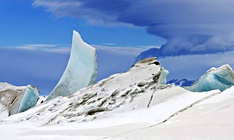
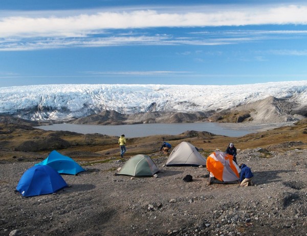
The Kluane/Wrangell-St. Elias/Glacier Bay/Tatshenshini-Alsek national parks and protected areas along the boundary of Canada and the United States of America are the largest non-polar icefield in the world and contain examples of some of the world’s longest and most spectacular glaciers. Characterized by high mountains, icefields and glaciers, the property transitions from northern interior to coastal biogeoclimatic zones, resulting in high biodiversity with plant and animal communities ranging from marine, coastal forest, montane, sub-alpine and alpine tundra, all in various successional stages. The Tatshenshini and Alsek river valleys are pivotal because they allow ice-free linkages from coast to interior for plant and animal migration. The parks demonstrate some of the best examples of glaciation and modification of landscape by glacial action in a region still tectonically active, spectacularly beautiful, and where natural processes prevail.


Sea otters | Glacier Bay

Sea otters, like this one, from #WorldHeritage Glacier Bay have more hair than any other mammal - up to 1 million hairs per square inch. Humans only have about 20.000 on the entire head. 

Sea otters are a threatened species, and like over half of the world's marine species, risk becoming extinct by 2100. Biodiversity is vital for the health of our planet & our societies. 

Visit World Heritage Marine Program (UNESCO) and The Kluane/Wrangell-St. Elias/Glacier Bay/Tatshenshini-Alsek

These parks comprise an impressive complex of glaciers and high peaks on both sides of the border between Canada (Yukon Territory and British Columbia) and the United States (Alaska). The spectacular natural landscapes are home to many grizzly bears, caribou and Dall's sheep. The site contains the largest non-polar icefield in the world.

Considerando a grande importância da biodiversidade, é imperativo perservá-la cada vez mais.

Feliz Dia da Biodiversidade !
Happy International Day for Biological Diversity !

Geração 'explorer'


22.05.2014


Creative Commons License

Sunday, May 18, 2014

Glaciar da Antárctida : perda irreversível


Thwaites Glacier
foto: NASA

Um novo estudo conduzido por pesquisadores da NASA mostra que glaciares na camada de gelo da Antárctida Ocidental estão em declínio irreversível. A sua fusão, alastrando gigantes gelados, afectará os níveis globais do mar nos próximos séculos.


 Mapa da Antarctica mostra Amundsen Sea
http://www.nasa.gov/


O colapso catastrófico do maciço de gelo da Antárctida Ocidental está em andamento, disseram no dia 12 de Maio investigadores. 

Os maiores glaciares no oeste da Antárctida estão a derreter sem qualquer forma de se poder conter a perda, afirmam dois estudos independentes.

O degelo imparável é o início provável de um efeito dominó há muito temido, que poderá causar o degelo de toda a camada de gelo, ou a não diminuição quer as emissões de gases de efeito estufa diminuam ou não.


"A diminuição dos glaciares manter-se-á durante décadas e até séculos e nós não podemos pará-lo", disse o principal autor do estudo, Eric Rignot, glaciologista da Universidade da Califórnia, e do Jet Propulsion Laboratory, da NASA.

"Um amplo sector do manto de gelo da Antárctida Ocidental passou o ponto de não retorno".

Eric Rignot

O maciço gelado da Antárctida ocidental detém 10 por cento do gelo da Antártida. Os glaciares aqui ficam com a sua base abaixo do nível do mar, derretendo de forma 
preocupante desde os anos 1970.

Os cientistas da NASA afirmaram durante uma teleconferência transmitida via online, nesse dia 12 Maio, que se tinham reunido observações suficientes para concluir que o recuo do gelo no mar do sector Amundsen da Antártida Ocidental se tornou imparável, com consequências importantes.  Isto significa que o nível do mar vai subir um metro em todo o mundo. 

Além do mais, o seu desaparecimento, provavelmente, desencadeará o colapso do resto da camada de gelo da Antárctida Ocidental, que trará um umento do nível do mar de três e cinco metros. Tal evento irá deslocar milhões de pessoas em todo o mundo. 

Podem ver a animação feita pela NASA no video abaixo:


Dois séculos - se isso é o tempo previsto - pode parecer muito tempo, mas não há nenhum botão vermelho para parar este processo. Reverter o sistema climático ao que era na década de 1970 parece improvável; mal podemos controlar as emissões que triplicaram desde o protocolo de Kyoto, e que foi projectado para atingir as metas de redução. 

Retardar o aquecimento global continua a ser uma boa ideia, no entanto o sistema da Antárctida, levará mais tempo para chegar a este ponto. 

A extensão do mar Amundsen é quase tão grande como a França. Seis galciares drenam-no. Os dois maiores são o glaciar Pine Island (30km de largura) e o glaciar Thwaites (100km de largura). Eles se estender por 500 km.

Imbatível o aquecimento climático de diversos graus durante o próximo século é provável que acele o colapso da Antártida Ocidental. Mas também pode desencadear a retirada irreversível de sectores baseados em marinhas da Antárctida Oriental. Se devemos fazer algo sobre isso, é uma questão de bom senso. E o momento de agir é agora: a Antártida não espera por nós.

O Dia do Planeta 2013 alertava já para as alterações climáticas. Igualmente na nossa postagem Alterações do glaciar  Ngozumpa (2012) se falava neste perigo para todo o ambiente.


Ross Island, Antarctica
foto: Michael Studinger/EPA
Nasa ice-monitoring team
http://static.guim.co.uk/

The West Antarctic Ice Sheet is one of the keys to global sea level rise. Running up against the Amundsen Sea, it contains an estimated 527,808 cu. miles (2.2 million cu. km) of ice, about 10% of Antarctica’s total land ice volume. That’s enough ice to raise global sea level by more than 15 ft. (4.6 m) were it all to melt, collapse and flow into the ocean, which in turn would swamp coastal cities as far inland as Washington, D.C. And according to new research, that’s exactly what’s beginning to happen.


Researchers from the University of California, Irvine, and NASA’s Jet Propulsion Laboratory have found that the group of six glaciers on the ice sheet directly draining into the Amundsen Sea are rapidly melting, as warming ocean water eats away at the base of the ice shelf. That’s making the ice around the West Antarctic Ice Sheet increasingly unstable—and the researchers could find no clear geographical obstacle that would slow down the retreat of the glaciers. Essentially, that means these glaciers—which collectively hold enough ice to boost sea levels by 4 ft (1.2 m)—”have passed the point of no return,” Eric Rignot, a glaciologist with UC-Irvine and NASA and the lead author on the paper, said in a statement. “The retreat of this ice seems to be unstoppable.” Read more here


Credits : video ScienceAtNASA

The new study led by NASA researchers shows that half-a-dozen key glaciers in the West Antarctic Ice Sheet are in irreversible decline. The melting of these sprawling icy giants will affect global sea levels in the centuries ahead.

Watch the images and videos on NASA website 

Earth Day 2013's theme was "The Face of Climate Change" to highlight growing impact on individuals through interactive digital campaign.

The same theme on our post The Nepalese Himalayas have been warming significantly more than the global mean temperature in recent decades. 

Let's end this acceleration glacier mass loss! Showing our "face od climate chage".

Tudo isto nos assusta e faz pensar como é possível que os países industrialisados insistam nas suas políticas que vão contra o meio ambiente e aumentam o aquecimento global.

Geração 'explorer'


18.05.2014

Creative Commons License

Referências:

Credits : videos | Photography NASA

Ciência Online

Tme ! Environment


Monday, May 5, 2014

Paisagem pré-histórica sob gelo na Gronelândia


Photo : Paul Bierman | University of Vermont

Cientistas da Universidade de Vermont, (Estados Unidos) foram surpreendidos com a descoberta de vestígios de uma paisagem pré-histórica por baixo da camada de gelo com 3.200 metros de profundidade, da Gronelândia.


“Encontrámos solo orgânico que se manteve preservado por baixo da camada de gelo durante 2.7 milhões de anos”, conta o geólogo Paul Bierman, da Universidade de Vermont, em comunicado de imprensa.

Esta descoberta indica que a camada de gelo da Gronelândia poderá existir há muito mais tempo do que se pensava, tendo ‘sobrevivido’ a diversos períodos de aquecimento global. A descoberta foi divulgada este mês no journalScience.

A Gronelândia é um local de grande interesse científico e ambiental uma vez que a sua camada de gelo (a segunda maior do mundo depois da Antártica) poderá influenciar, em caso de aquecimento, a subida do nível do mar.


Photo : Paul Bierman | University of Vermont

De acordo com os dados analisados, este solo enterrado por baixo da Gronelândia terá estado exposto algures entre 200.000 e um milhão de anos antes da camada de gelo se ter formado.

Além do berílio, a equipa mediu o nitrogénio e o carbono que teriam sido deixados pela flora da tundra pré-histórica, sendo que encontraram vários vestígios de material orgânico cuja composição sugere a presença de uma zona florestada.

“A Gronelândia (em inglês ‘Greenland’, que significa ‘terra verde’) era realmente verde! Contudo, essa paisagem existiu há milhões de anos atrás”, diz um outro membro da equipa, Dylan Rood. “A Gronelândia seria semelhante à zona verde do Alasca, antes de ter sido coberta pela camada de gelo”, conclui. Ler mais aqui


Photo : Joshua Brown | University of Vermont

Glaciers are commonly thought to work like a belt sander. As they move over the land they scrape off everything — vegetation, soil, and even the top layer of bedrock. So scientists were greatly surprised to discover an ancient tundra landscape preserved under the Greenland Ice Sheet, below two miles of ice.


“We found organic soil that has been frozen to the bottom of the ice sheet for 2.7 million years,” said University of Vermont geologist Paul Bierman — providing strong evidence that the Greenland Ice Sheet has persisted much longer than previously known, enduring through many past periods of global warming.

He led an international team of scientists that reported their discovery on April 17 in the journalScience. Read more here

Geração 'explorer'

05.05.2014

Creative Commons License

Friday, April 25, 2014

Escolas : Feliz Dia do Pinguim !


Gentoo Penguins on Saunders Island. 


Sabias que hoje é o Dia do Pinguim? Pois cá estamos nós a celebrar este belo animal polar.


Feliz Dia do Pinguim !


Hoje, 25 de Abril é Dia do Pinguim ! Impossível imaginar o mundo onde não houvesse pinguins. De modo a celebrar os nossos divertidos amigos de barbatanas finas, talvez seja bom reunir algumas curiosidades sobre pinguins. 

Umas são divertidas, outras são factos, e ainda outras a junção das duas características - divertidas e factos - ao mesmo tempo.


Gentoo Penguin
créditos: Autor não identificado


Todos os pinguins selvagens vivem no Hemisfério Sul e embora seja sinónimo de gelo, apenas duas espécies vivem no continente da Antárctida. 

O pinguim de Galápagos é o único pinguim que já se aventura naturalmente no Hemisfério Norte em viagens bastante longas,  à procura de alimentação. Ler mais aqui


Até já postamos sobre Happy Feet, esse filme delicioso.


 credits: Giuseppe Zibordi/Michael Van Woert/

NOAA NESDIS, ORA


Depois divulgámos o belíssimo filme Where Penguins Live, um filme de Greenpeace USA que nos deixa sem palavras.


credits : video Greenpeace USA

Também divulgámos o Pinguim no Dia da Terra 2011 neste outro vídeo Ice Planet Penguins


credits :video BBC Earth


Happy World Penguin Day everyone! Did you know it ?

"It’s World Penguin Day today, April 25th, and I simply can’t imagine a world that didn’t have penguins in it. So in order to celebrate our funny fine-flippered friends I thought it would be good to pull together some fun facts about penguins. Some are fun, some are facts, and some are both at once."

Willie, Greenpeace


Baby Penguin
credits unknown
http://www.google.com/


All wild penguins live in the Southern Hemisphere, and although they are synonymous with the ice, only two species live on the continent of Antarctica. The Galapagos penguin is the only penguin that ever naturally ventures into the Northern Hemisphere on especially long feeding trips. Read more here

Well, we wrote about penguins several times! Here some posts: Penguin ; Penguin Emperor ; Research on Penguins with metal trackers ; Penguins found dead in Brazil

We wrote about the awesome animated film Happy Feet, remember ?


We think you watched the videos above :  Where Penguins Live ;  Penguins Earth Day 2011. Wonderful !


credits: Liam Quinn/ Flickr

What's your favourite species?

Is it little blue penguins like these? These guys were released back into the wild in 2011 after being rescued and cleaned up following the Rena oil spill disaster

These little blue penguins were contaminated by oil after the Rena Oil Spill disaster in New Zealand. They were released into the ocean in 2011 after being cleaned at the oiled wildlife facility.


Esperamos que goste desta celebração do Dia do Pinguim.

Hope you like our Penguin Day celebration.


Geração 'explorer'

25.04.2014

Creative Commons License


Tuesday, April 15, 2014

Escolas : Titanic, tributo National Geographic : recursos !


Titanic (imagem virtual)


Neste dia, 15 Abril, o mundo prestou tributo a Titanic e a todos os que pereceram nesse fatídico choque com um icebergue, cinco dias depois de ter largado do porto de Southampton, Inglaterra, ao tentar fazer a travessia até Nova Iorque, Estados Unidos.


Titanic: Jornal da época


Considerado inafundável, Titanic era um transatlântico de luxo  com lotação para 2 000 passageiros e tripulantes. Em 15 de abril, o Titanic afundou-se em poucas horas, depois colidir com um icebergue durante a noite.

Cento e dois anos depois, o National Geographic Education marca esta data, uma das maiores tragédias da história marítima.


On his 1986 trip down to the Titanic, Robert Ballard and his team left a commemorative plaque on the deck of the sunken R.M.S. Titanic

Estão disponibilizados variados recursos educativos que vão da construção do Titanic em Belfast, na Irlanda, até à sua descoberta em águas geladas, em 1985, pelo explorador residente Robert Ballard e pelo oceanógrafo Jean-Louis Michel da equipa do National Geographic.

O Titanic há muito cativou o público em geral. E nas escolas, professores e alunos dedicam todos os anos algumas aulas a estudar e rever a história deste transatlântico que terminou tão tragicamente.

Deste modo, achamos por bem divulgar todos os recursos multimédia disponibilizados canal National Geographic e que tem por título Remembering the Titanic.

É o nosso tributo a todos as vítimas do doloroso e trágico naufrágio do Titanic.


Titanic death


On April 10, 1912, the R.M.S. Titanic left its port in Southampton, England, and began the transatlantic journey to New York City in the United States. 

Considered unsinkable, Titanic served as a luxury ocean liner for over 2,000 passengers and crew. On April 15, Titanic sank in just over two and a half hours after colliding with an iceberg


Titanic
 (A series of commemorative postcards was issued in New Jersey shortly after the sinking of the Titanic)

More than one hundred years later, National Geographic Education marks the centenary anniversary of one of the greatest maritime tragedies in history on the online project Remembering the Titanic.

From Titanic’s construction in Belfast, Ireland, to its discovery under icy waters by National Geographic Explorer-in-Residence Robert Ballard and oceanographer Jean-Louis Michel in 1985, the Titanic has long captivated the public mind. 


Titanic
An intact glass pane from the window of Captain Edward J. Smith's cabin hangs open on the sunken Titanic

Use this collection of multimedia education resources in your in-person class to contextualize the anniversary for your students. 


As students, this is our tribute to all the passengers and crew who died 100 years ago, Titanic.


Geração 'explorer'

15.04.2014

update: 15.04.2022


Licença Creative Commons

Images: credits National Geographic