Saturday, June 21, 2014

Cientistas em nova odisseia fundo dos mares : Aquatilis


Expedição Aquatilis

Uma equipa de 12 jovens cientistas, liderada pelo biólogo marinho Alexander Semenov, vai aventurar-se numa "viagem submarina" de três anos, para explorar as profundezas do mar.


Alexander Semenov, responsável projecto


A expedição denomina-se Aquatilis. Os investigadores irão "descobrir" mais de 56 mil kms entre os Oceanos Atlântico, Pacífico e Índico em busca de novas espécies de seres marinhos, a bordo de um navio de 21 metros, feito sob medida para a missão. 


créditos : Aquatilis


A saída está programada desde MarmarisTurquia, durante o verão de 2015. Até lá, a equipa está a angariar o financiamento necessário para tornar esta "viagem de sonho" uma realidade. 


créditos : Aquatilis

O projecto está por isso no Indiegogopara angariação de fundos a quem quiser dar o seu contributo financeiro. 


Os pormenores da viagem e sua missão e objetivos são explicados a partir do enedereço http://aquatilis.tv, com muitas imagens "tentadoras" à mistura. 

Podem seguir Aquatilis nas redes socias : FacebookTwitterInstagram.


credits : Aquatilis

Aquatilis Expedition is an epic three-year underwater journey through the unknown, set to explore the world’s most extraordinary creatures.

The team is led by  Alexander Semenov, a marine biologist, a world-renowned underwater photographer, a scientific advocate.


Aquatilis ship
Credits : Aquatilis


Aquatilis scientists
credits : Aquatilis

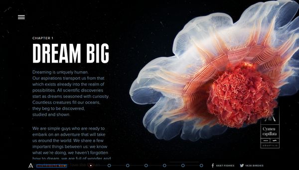
"As humans, we are naturally attracted to the exploration of our world. Our curiosity leads us to explore the most remote parts of the Earth, from the top of Mount Everest to the middle of the Pacific Ocean. We are drawn to novelty. 


Jacques Cousteau
credits: Cousteau

In childhood, many of us were fascinated by the travels of Jacques-Yves Cousteau who showed us, landlocked, the depths of the sea, by the underwater mysteries uncovered by Robert Ballard, or else by the exploits of Sir David Attenborough, whose calm poise helped us witness extraordinary inhabitants of the Earth."

in Aquatilis, Dream, Progress & Exploration, chapter1

Here's a link to Aquatilis crowdfunding page here


The expedition will involve lots of cool things: satellite broadcasting from distant corners of the world, a custom-made remotely-operated underwater robot with a built-in 4K camera, handsome hard-working scientists but, best of all, plenty of fresh juicy knowledge for everyone. 

The team believe it’s time for a new Underwater Odyssey fit for the 21st century, an expedition that uses the full scope of possibilities that modern technologies and media have to offer. Read more here

Follow Aquatilis on social networks : FacebookTwitterInstagram.

We will be following this expedition in 2015 ! 

Nós estaremos atentos a esta expedição em 2015 !

Geração 'explorer'

21.06.2014

Creative Commons License

Wednesday, June 18, 2014

Submundo descoberto na Gronelândia


greenland_com / Creative Commons
Foi descoberto um submundo debaixo da vasta camada de gelo da Gronelândia, segundo um estudo publicado no jornal Nature Geoscience
A vasta camada de gelo cobre o o Norte da Gronelândia e foi descoberta por um radar que penetra no gelo, durante um dos vôos de pesquisa da NASA.
De acordo com a equipa de investigadores, esta descoberta pode aprofundar o nosso conhecimento sobre a forma como as camadas de gelo da Gronelândia e Antárctida respondem às alterações climáticas.
“Cada vez vemos mais esse fenómeno – a camada de gelo começa a derreter mais rápido” (...) “Acreditamos que o processo de recongelamento eleva, distorce e aquece o gelo acima, tornando-se mais suave e mais fácil de fluir”.
Robin Bell, autor principal do estudo e geofísico do Lamont Doherty Earth Observatory, da Universidade de Columbia. 


greenland_com / Creative Commons
Até agora, os cientistas pensavam que as formas que distinguiam abaixo da camada de gelo eram cadeias montanhosas. Agora, com as pesquisas da NASA sabe-se que estas formações são gelo e não rocha.
As formações foram causadas pelo derretimento e subsequente recongelamento da água no fundo da camada de gelo. 
A descoberta é tão impressionante que deixa os cientistas mostraram incrédulos com os resultados.
“É algo espectacular. São apenas linhas paralelas planas. O gelo é suposto ser assim, mas aqui está a quebrar todas as regras. São coisas onduladas, distorcidas e loucas, que se encontram debaixo do gelo e são do tamanho de arranha-céus”, 
Kirsty Tinto, geofísica de Lamont-Doherty.


greenland_com / Creative Commons
As estruturas cobrem cerca de 10% das áreas da Gronelândia do norte pesquisadas pela NASA. 

O derretimento e recongelamento da camada de gelo desenrola-se há centenas ou milhares de anos. Os cientistas já tinham conhecimento destes processos, mas só agora perceberam o que as áreas derretidas estavam a recongelar.
Esta investigação é crucial para perceber como devemos responder às alterações climáticas. “Se queremos perceber de que forma o gelo está a responder às alterações climáticas, temos de perceber a sua dinâmica fundamental”

Kirsty Tinto.
“Não é apenas saber que estamos a derreter a superfície e que esta superfície está a correr para o mar. Há um sistema lindo e complicado através do gelo e temos de percebê-lo do topo ao fundo para saber o que se está a passar”.


Melting and refreezing at the bottom of ice sheets warps the layer-cake structure above, as seen in this radar image from Greenland. 

Credit: Mike Wolovick


The mostly flat topography of Greenland is in sharp contrast to the jagged features found to be underlying much of the ice sheet. 

Scientists have discovered a frozen underworld beneath the ice sheet covering northern Greenland.
Beneath the barren whiteness of Greenland, a mysterious world has popped into view. Using ice-penetrating radar, researchers have discovered ragged blocks of ice as tall as city skyscrapers and as wide as the island of Manhattan at the very bottom of the ice sheet, apparently formed as water beneath the ice refreezes and warps the surrounding ice upwards.

Uplifted and deformed ice sheet in the fast flowing Petermann Glacier as seen in this radar image from Greenland. 
Credit: Mike Wolovick

The newly revealed forms may help scientists understand more about how  sheets behave and how they will respond to a warming climate. The results are published in the latest issue of Nature Geoscience.
"We see more of these features where the  starts to go fast," said the study's lead author, Robin Bell, a geophysicist at Columbia University's Lamont-Doherty Earth Observatory. "We think the refreezing process uplifts, distorts and warms the ice above, making it softer and easier to flow." Read more here
As alterações climáticas estão na ordem do dia e são cada vez mais uma das preocupações de muitos dos cientistas mundiais.

Geração 'explorer'
18.06.2014
Creative Commons License
Referências :
GreenSavers Portugal
Phys Org

Sunday, June 8, 2014

Dia Mundial dos Oceanos ! Im Planeta, um Oceano !


"The ocean is essential to our well-being and the future of our planet, and World Oceans Day is a moment for all Governments and all societies to join forces in ensuring its protection. 
One Planet, One Ocean – Together, we have the power to protect them both. "

Irina Bokova, Directora-Geral UNESCO

Hoje é Dia Mundial dos Oceanos. Depois de celebrarmos o Dia Internacional da Biodiversidade, Dia Mundial do Meio Ambienteeis-nos de novo a chamar  a atenção para o Dia Mundial dos Oceanos.

Tema:

"Um Planeta, um Oceano, juntos podemos protegê-los".

O tema do Dia Mundial dos Oceanos 2014 é "Um Planeta, um Oceano, juntos podemos protegê-los".

Os oceanos ocupam dois terços da superfície da Terra e pela interacção com a atmosfera, litosfera e biosfera têm um papel importante nas condições climatéricas do planeta. 

Por outro lado, os oceanos não são apenas o habitat de um vasto número de plantas e animais. Fornecem também comida, energia e múltiplos recursos aos seres humanos.


World Oceans map

Os oceanos são ainda o principal regulador térmico do planeta, absorvendo mais de um quarto do dióxido de carbono libertado pelas actividades humanas.

Em 1992 durante a conferência RIO 92 foi estabelecida a data de 8 de Junho como o Dia dos Oceanos. 

Em 1994 a comunidade internacional deu um passo importante para a protecção dos oceanos, particularmente através de um decreto oficial da Convenção das Nações Unidas para o Direito do Mar. 

Um dos principais assuntos, além da preservação da fauna e da flora, é a protecção das populações de algumas espécies como o atum, tubarão, peixe espada e merlin.

Em 2008, as Nações Unidas decidiram que o dia 8 de Junho passaria a ser designado como o Dia Mundial dos Oceanos. Vários países celebram a data, mostrando a importância dos oceanos no clima e como elemento essencial da biosfera.


Mapa Portugal é Mar

Portugal é um país oceânico. O Oceano marcou o desenvolvimento do nosso país, com as trocas comerciais, culturais e científicas durante a época dos descobrimentos.  

A expansão oceânica definiu o património arqueológico, cultural e histórico português até aos dias de hoje. 76 % da população portuguesa reside nas áreas costeiras.

Portugal tem uma faixa costeira de 1.187 km e a terceira maior Zona Económica Exclusiva (ZEE) da Europa, 18 vezes superior ao território continental do país. 

Foi submetida às Nações Unidas uma proposta de alargamento dessa ZEE, que a ser aprovada traz benefícios em termos de exploração de energia, recursos minerais, biodiversidade e investigação científica.

O Oceano é uma componente decisiva da História, Geografia do País, tendo-lhe conferido desde sempre uma posição geo-estratégica relevante nas relações com a Europa, a Améria e África. 


Today, we celebrate World Oceans Day. May 22 we celebrated the International Day for Biological Diversity (IDB) to increase understanding and awareness of biodiversity issues. And June 5, World Envioronment Day.

Portugal is an Ocean country. The Sea is a mean of communication and transportation, a source of food and medicines, of energy and living resources. The Ocean creates employment and promotes the economy of the country.


Portugal is Sea map

Parallel, the sea and coastal areas play an essential role in people’s welfare and quality of life, through sport and leisure activities, as well as the ecosystem services they provide.

The celebration of World Oceans Day 2014 coincides with the first day of the twenty-fourth meeting of the Meeting of States Parties to the United Nations Convention on the Law of the Sea. This year, also marks the twentieth anniversary of the entry into force of the Convention.

The United Nations will celebrate World Oceans Day 2014 and recognize the winners of the Annual World Oceans Day Oceanic Photo Competition at an event on 9 June 2014 at United Nations Headquarters.


On World Oceans Day people around our blue planet celebrate and honor the ocean, which links us all. 

To commemorate World Oceans Day, the United Nations family is encouraging the international community to reflect on the multiple benefits of oceans and commit to keeping them healthy and productive for current and future generations.


“We have to ensure that oceans continue to meet our needs without compromising those of future generations. They regulate the planet’s climate and are a significant source of nutrition. Their surface provides essential passage for global trade, while their depths hold current and future solutions to humanity’s energy needs.”
Secretary-General Ban Ki-moon

Protejamos juntos os Oceanos !
Let's protect the Oceans together !

Geração 'explorer'
Creative Commons License